Reconnecting the rivers
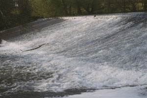
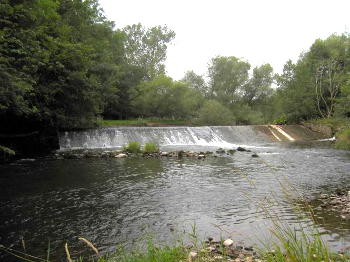
Our first walk-over survey of the upper Wye (1995/6) showed that less than 50% of spawning habitat for salmon (by area) and less than a quarter of trout spawning habitat was available to ascending fish. A combination of neglect and poor regulation had allowed weirs, badly designed crossing points and road culverts to be built without the requirement for free passage of fish. These were the main culprits but huge debris dams had also formed on an alarming number of tributaries, completely sealing off hundreds of kilometres of essential spawning and nursery habitat. For salmon this was disastrous and unquestionably the main cause of their decline, particularly the loss of the Lugg and its tributaries in the 1980s.
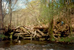
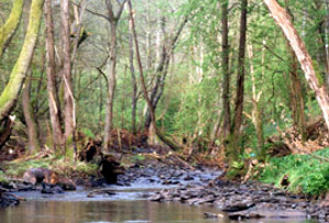
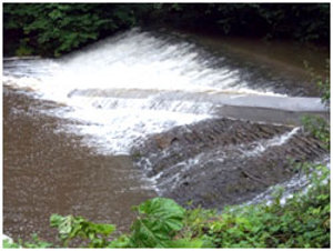
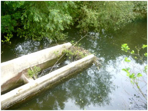
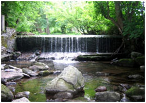
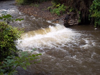
A timber dam was found blocking the Sgithwen, an important upper Wye spawning tributary. The right hand photo shows the stream reopened by the Foundation after just a few hours work.
Small populations of brown trout remained above the blockages but the larger main channel residents, which provided the bulk of the egg deposition, were prevented from reaching the ideal (smaller) sized tributaries. The extent of the decline of brown trout as indicated by juvenile densities was even greater than that of salmon in the Wye by 1996.
Between 1996 and 1997 the Foundation embarked on a programme to reopen the tributaries of the upper Wye. The experience of the Tweed, North Esk and elsewhere showed that this is the single most cost effective way of increasing fish populations. The programme took two years, including surveying, and reopened 132km of salmon and 330km of trout spawning areas. Since then, the work has continued and as of 2013, there are just a few sites on the lower Usk, Wye and Lugg that require fish passes.
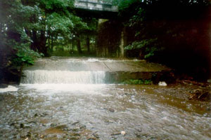
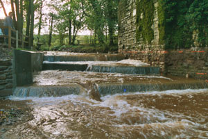
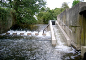
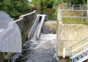
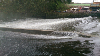
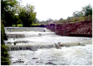
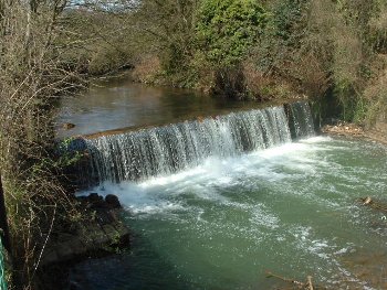
The lower weir on the Digedi before and after the Foundation built
a fish pass
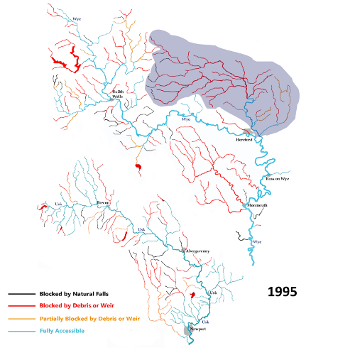
After this initial effort, the Foundation has continued opening or reopening Wye and Usk streams and rivers as part of the following projects: WHIP , pHish , UP! , Leader+ , Lugg & Arrow, Radnor Foal , ART/Defra and WHIP2. The current and historical situations are detailed on the maps below which show the extent of the Wye and Usk catchment upstream that was blocked to migrating fish in 1972. Click on the dates to the left of the map to see the situation in 1995, 2009 and the amount of river that will be open in 2015, if we manage to complete our plans.
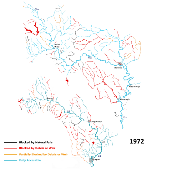
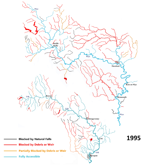
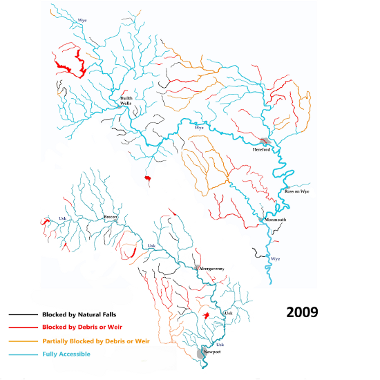
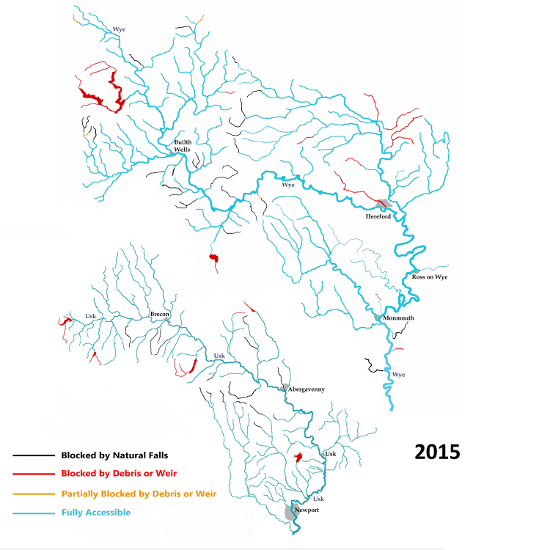
Red: Access barred to migrating fish by weirs, timber blockages etc
Black: Areas of the catchment that are permanently blocked - natural waterfalls,
Elan Valley Dams etc.
 THE LUGG & ARROW
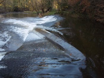
The Lugg and Arrow (the Wye's largest tributary system) has numerous barriers, which were built in the 18th and 19th centuries to control flooding and erosion, and to provide a water supply for agriculture and milling. Until the early 1980s, the catchment was accessible enough to enable up to 3,000 salmon redds to be recorded in a favourable year. However, in 1982 the Leominster Flood Alleviation Scheme sealed off the Lugg and the run dwindled to a few persistent pairs of salmon. This was partially corrected with a modern Larinier fish pass built at Hampton Court in 2003 and with two passes at Leominster in 2004.The next phase was to secure full access over the historic weirs and this will be completed in 2015.
Fish passes on the River Lugg at Leominster, built by the EAW in 2004. Before these were completed migrating fish were unable to progress any further.
River Arrow Baulk Passes: Hunton, Titley on the left and Downfield on the right, both built by WUF in 2010..

An EA fish pass at Holgate's weir on the River Lugg just downstream of Kingsland. The pass persistently blocked with debris but after modifications to WUF specifications (above right) this is much less likely.
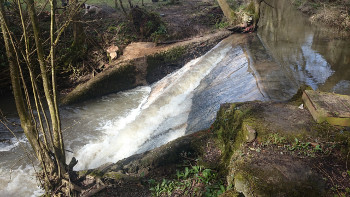
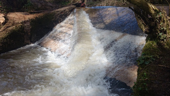
The WUF-built fish pass at Dayhouse weir on the Lugg, completed in October 2014.
The fish pass completed on the Lime Brook, a Lugg tributary, in 2015.
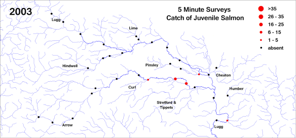
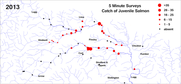
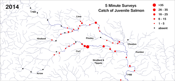
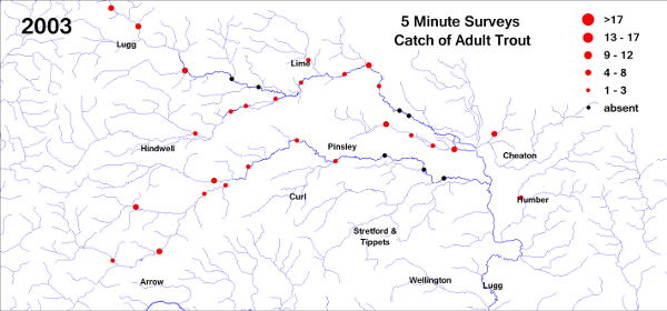
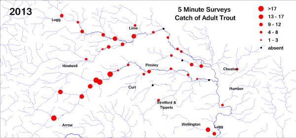
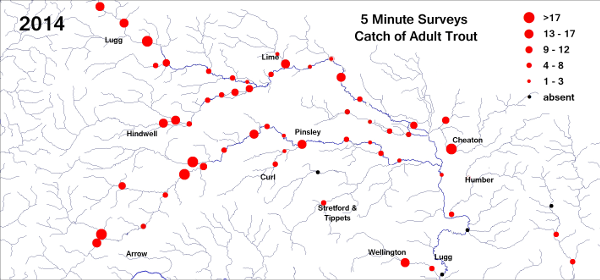
LUGG & ARROW - Results
The maps below show the effect the work to restore access has had on salmon and trout populations. The first map is derived from electrofishing surveys in 2003. To contrast it with the 2013 survey, click on the 2013 link in the map titles.
Lugg and Arrow Electrofishing Surveys – Atlantic salmon, 2003, 2013 and 2014
Lugg and Arrow Electrofishing Surveys – Brown Trout, 2003, 2013 and 2014
 THE MONNOW
The Monnow was closed to salmon in 1917 when Osbaston weir was built to generate electricity for Monmouth. Upstream weirs at Skenfrith (washed out by the floods of 2000) and at Kentchurch prevented access to what amounted to be 17% of the Wye catchment. A project between EAW and the owner of the land at Osbaston resulted in an innovative scheme to create fish passage and generate electricity. The two Archimedes screws are described as "fish friendly".
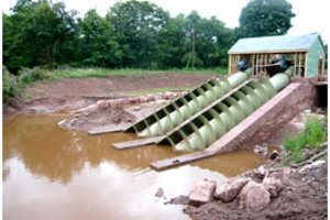
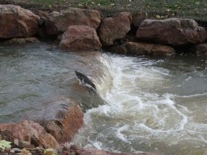
Above left: the previously impassable Osbaston weir, prior to the hydropower (above right) and fish pass scheme (below left). A salmon passing through the fish pass (below right), completed by the EAW in August 2008.
In August 2011 EAW breached the left hand side of Kentchurch weir on the Monnow. Fish should now be able passage to get to all five of the main tributaries upstream, (although there are some structures in these that will need to checked.) The remainder of the work consists of removing the rest of the structure and making good the surrounding area. The benefit to salmon, sea and brown trout will be enormous.
USK
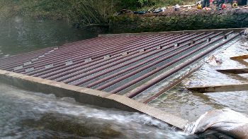
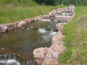
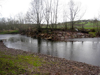
In 2004 we turned our attention to the Usk and found that while the river above Brecon is mainly unobstructed, the catchment from Brecon to Abergavenny was as bad as on the upper Wye in 1995 with every major tributary having at least one serious obstruction. Our tour de force was the construction of a fish pass in 2006 on the Cynrig - a stream that collects its rainfall from the steep slopes at the top of the Brecon Beacons.
The Abercynrig fish pass, showing the weir (left) that obstructed migration and the completed fish pass (right), which has opened up approximately 7kms of salmon & trout nursery area. One of the targets of our FOAL project (2010-2011) was to improve fish access to the Afon Lwyd, a lower Usk tributary. The photos below show a weir at Tynantddu, which we lowered in May 2010.
Milestones in improving Wye and Usk fish access:
-
1996/7 Upper Wye Access Project: Barrier removal and easement construction
-
2000 Flood washes out Skenfrith weir, Monnow
-
2003 pHish project - 7 fish passes
-
2003 Hampton Court fish Pass opened R Lugg by EA Wales
-
2004 Lugg Flood alleviation scheme fish passes (EA Wales)
-
2004 UP! Project: Cilieni Weir removed
-
2006 Cynrig fish pass and weir removed Menasgin (UP)
-
2008 Osbaston Fish Pass (Monnow)
-
2008 12 Lugg and Lower Arrow easements completed. (EAW and Leader+)
-
2010 Four more fish passes completed on Arrow to take fish to Kington. Three Lugg fish passes modified by EAW below Kingsland. Six eaements or removals on the Garren. (Art/Defra)
2011 EA Wales breaches and removes the weir at Kentchurch, opening up a huge spawning area on the Monnow system
-
2010 Two Weirs lowered on the Afon Lwyd (Usk tributary) Pontypool and Cwmafon
-
2011 Further improvements to upper Lugg and Arrow access with 8 more fish easements. (Art/Defra, EFF in Wales & WHIP2)
-
2012 Easements completed at Ffrwd, Berthin, Rhyd Y Meirch (Usk) (EFF)
-
2013 Passes at Downfield and Mahollam (Arrow) completed and temporary easement at Dayhouse (Lugg)
-
2014 Permanent Low Cost Baffle (LCB) system passes completed at Cyff, Gwy and Iago tributaries at Pumlumon, upper Wye. Barriers removed from upper Tarenig, Pumlumon (EFF)
-
2014 Permanent LCB pass plus eel pass completed at Dayhouse weir, R Lugg (WHIP2)
-
2015 Bypass on Gilwern repaired and Baulk completed on Lime Brook, a Lugg tributary
-
2015 Easement completed on Nant Meity (R Usk)
With thanks to our partners the Environment Agency, Countryside Council for Wales and the many other funders.
![]()
![]()
![]()